
A riding record from a motorcyclist who brought his own motorcycle from Australia to Japan and rode forest roads in various locations from October to November 2026. His beloved bike is a Honda adventure model, an Africa Twin (CRF1100L). He calls it “Silver.”
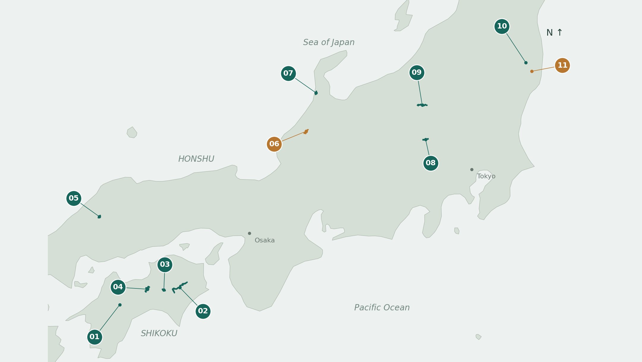
The record covers 11 routes, including the Tsurugisan Super Forest Road and Tenkū no Rindō in Shikoku, the Mikabo Super Forest Road in Gunma Prefecture, and the Chirihama Nagisa Driveway in Ishikawa Prefecture. We’ve compiled the actual road surface conditions experienced on a large adventure motorcycle loaded with gear, photographs, reference coordinates, and GPX files.
What makes this record special
- Actual riding experience:Based on riding an Africa Twin that weighed about 300 kg when loaded with gear, the record describes road surfaces including compacted gravel, loose rocks, muddy sections, and fallen leaves.
- Reference coordinates and GPX:Each record includes reference coordinates for entrances and junctions (which can be opened in Google Maps) and GPX files of the riding records.
- Records of turnarounds included:The record includes turnarounds at broken bridges, deep drainage ditches, bear sightings, and sections that were planned but not ridden, all recorded as they happened.
- Bilingual English and Japanese:There are both the original English text written by the rider and a Japanese version (06 is English only, so the Japanese translation is by Good Loop).
Ride list (by region)
Forest roads in Shikoku (Ehime, Kochi, Tokushima)
- 01 Tenkū no Rindō
October 21 | Shikoku | Round trip on ridge road (GPX) - 02 Tsurugisan Super Forest Road
October 23 & 28 | Shikoku | Includes paved detour (GPX) - 03 From Kyobashira toward Yahazu Pass
October 27 | Shikoku | Turned back at broken bridge (GPX) - 04 Niogauchi, Ryūō, Sakuyashiki
October 29 | Shikoku | Junctions and paved connecting roads (GPX)
Forest roads in the Chūgoku region (Misato, Shimane Prefecture)
- 05 Shindōro Forest Road (Misato, Shimane Prefecture): Following forest junctions
November 1 | Shimane | Exploring forest junctions (GPX)
Forest roads and sandy roads in the Hokuriku region (Ishikawa Prefecture)
- 06 From Komatsu & Ōyama Forest Road to Shika: The bear had already run off before I could record it
November 5 | Hokuriku | Planned route only, unpaved sections not ridden (GPX) - 07 Chirihama Nagisa Driveway
November 6 | Ishikawa | Sandy section recorded (GPX)
Forest roads in Gunma Prefecture
- 08 Mikabo Super Forest Road
November 11 | Gunma | 13.5 km section excerpted and recorded (GPX) - 09 Manzawa & Akishika-Ōkage Forest Road
November 12–13 | Gunma | Both directions recorded (GPX)
Roads in Fukushima Prefecture (around Iwaki)
- 10 Takine Ojiroi & roads around the wind turbines
November 14 | Fukushima | Explored around wind turbine area (GPX) - 11 Iwaki north loop (incomplete)
November 14 | Fukushima | Planned loop not completed (GPX)
These are past riding records. Since forest road conditions change, please check current information with local authorities or managers before riding.
How the record was made: GPX and ChatGPT
While riding, the motorcyclist kept his helmet intercom on and recorded the route he rode as a GPX file using onboard equipment. After finishing, he used ChatGPT to cross-reference the GPX record with photo timestamps, identify the forest road entrances and exits, extract the necessary sections, and compile them into reports.
He says he started using ChatGPT this way after coming to Japan. In addition to making reports, he uses it for planning routes and destinations, editing GPX files, learning about towns and cities he passes through, and finding accommodations and restaurants that match his preferences.
GPX tracks are also very useful when adventure riding in Australia, he says, because Google Maps often doesn’t show unpaved roads he wants to ride or doesn’t suggest routes using those roads. He hopes this report and these GPX files will help other riders discover such places and reduce the effort needed to plan touring trips in Japan.
Before riding Japanese forest roads: Key takeaways from the record
This record contains several useful experiences for riding Japanese forest roads. Here are the main ones.
- Check road closures in advance:Forest roads can become impassable due to disasters, construction, or forestry work. On the day heading from Kyobashira toward Yahazu Pass, the bridge was broken so the rider turned back. On the Tsurugisan Super Forest Road, he also took a detour around a closure.
- Forest road entrances can be hard to find:Forest road entrances may be difficult to identify with just navigation apps or Google Maps. It’s reassuring to check coordinates and GPX files in advance.
- Watch out for bears:On the way to the Ōyama Forest Road (Ōyama Regional Main Forest Road) in Komatsu, Ishikawa Prefecture, a bear crossed the road, and bear warning signs were spotted on forest roads in Kochi Prefecture. He carefully considers whether to enter narrow forest roads alone.
- Plan for nightfall and refueling:Gas stations are scarce in mountainous areas and close early. In the Hokuriku records, he was able to refuel with about 1 liter remaining, just 5 minutes before the station closed.
- Don’t push it with a heavy bike:On deep drainage ditches or soft road surfaces, a large motorcycle loaded with gear can get stuck. He notes that a lighter bike or riding with companions makes exploring small side roads easier.
How to ride Japan on your own motorcycle from overseas
To travel in Japan on a motorcycle registered abroad, you need temporary import procedures (CPD carnet), Japanese compulsory automobile liability insurance (jibaiseki), an international driving permit, and more. You also need to decide in advance how to transport your motorcycle.
Good Loop supports motorcyclists coming from overseas by helping arrange transportation, prepare documents, and arrange storage and maintenance in Japan. For more details, see the pages below.
- Vehicle Concierge (rider support)
- International transportation (motorcycle import and export)
- Export and import guide
- Compulsory insurance sales
- How to proceed and contact us
Frequently asked questions
Can I use GPX files directly in my navigation system?
The GPX files are the rider’s actual riding records or simplified versions with fewer points. They were not created for route guidance, so use them as reference for route planning. The GPX for 06 is from the planning stage, not an actual riding record.
Are the forest roads shown here still passable?
Each record is from October to November 2026. Since forest road conditions change frequently, check with local authorities or managers about current access before riding.
Can you ride them on a large adventure motorcycle?
All these records were made riding a loaded Honda Africa Twin (CRF1100L). While some sections were easy to ride, others required careful progress or turnarounds because of loose rocks and deep drainage ditches. For details on road conditions, please see each record.